Categories
- 12V Accessories
- 4WD & TOURING
- 4WD & TOURING BARWORK & PROTECTION SIDE RAILS & STEPS
- 4WD & TOURING BARWORK & PROTECTION UNDERBODY PROTECTION
- 4WD & TOURING BARWORK & PROTECTION WINCH BARS / BULL BARS
- 4WD & TOURING Towing Mirrors
- 4WD TOURING
- 4X4
- 5th Wheel & Gooseneck
- ACCESORIES & TOURING
- ACCESORIES & TOURING Roof Rack Accessories
- ACCESSORIES
- Accessories
- Accessories
- ACCESSORIES
- ACCESSORIES
- ACCESSORIES & KITS
- ACCESSORIES 4x4 ACCESSORIES
- ACCESSORIES Power Pack
- BACKYARD & BEYOND
- Bash Plates
- Battery Trays
- BOOTS
- BULLBARS & PROTECTION
- BULLBARS & PROTECTION Front Protection Bars
- BULLBARS & PROTECTION Premium Roll Bar
- BULLBARS & PROTECTION Rear Carrier Bars
- BULLBARS & PROTECTION Rear Protection Bars
- BULLBARS & PROTECTION Rock Sliders - Side Setps
- BULLBARS & PROTECTION Rock Sliders - Side Setps
- BULLBARS & PROTECTION SINGLE LIGHT BAR
- BULLBARS & PROTECTION Sport bar
- BULLBARS & PROTECTION Steel Bullbars
- BULLBARS & PROTECTION Underbody Protection
- CAMPING & OUTDOOR
- CANOPIES & TRAYS
- CLASSIC SPORT BAR
- Clothing
- CLOTHING MENS JACKETS
- COMMUNICATIONS Accessories
- COMMUNICATIONS Accessories
- Diff Drop
- Dual Battery Management
- ELECTRICAL Battery Trays
- ELECTRICAL LIGHTING LED LIGHT BAR
- MARINE AUDIO
- MARINE CASES
- MARINE COMMUNICATIONS
- Performance
- PHOENIX BARS
- Rock Sliders & Bars
- Roll Bars
- SAFARI
- SAFARI
- Safety and Recovery
- SAFETY AND RECOVERY Recovery Point
- SAFETY AND RECOVERY Recovery Points
- SAMMITR
- Scanners
- SINGLE LIGHT BAR
- Snorkels
- SNORKELS
- Sport bar
- STORAGE
- SURVEILLANCE
- Suspension
- SWING SPORT BAR
- TOWING & TRAILERS
- TRAILER & TRUCK PARTS
- TYRE RACK
- UHF & TRANSCEIVERS
- UHF HANDHELD RADIOS
- WINCH BARS / BULL BARS
- WINCHES
- WINCHES & RECOVERY Electrical Winches
- NUDGE BARS
- REAR BARS & WHEEL
- ALUMINIUM BARS
- SIDE RAILS AND STEPS
- UNDERBODY PROTECTION
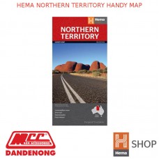
HEMA NORTHERN TERRITORY HANDY MAP
Product Details
- Brand: HEMA MAPS
- Product Code: 9781865009766
- Availability: In Stock
Description:
A fully indexed map of the Northern Territory
(NT) at a scale of 1:1,750,000. Marked on the map are national parks,
camping areas, rest areas, caravan parks, points of interest and 24-hour
fuel accompanied by a distance grid.
| HEMA MAPS SPECIFICATIONS | |
| Availability | Available |
| Best Scale | 1:1750000 |
| Cover Size Depth (mm) | 3 mm |
| Cover Size Height (mm) | 250 mm |
| Cover Size Width (mm) | 127 mm |
| Edition Number | 12 |
| Format | Folded Map |
| Publication Date | 01/06/2014 |
| Unfolded Size Height (mm) | 500 mm |
| Unfolded Size Width (mm) | 875 mm |


